A Far-Off Paddle: Jedediah Island
It sounded like a fairytale place, a far-flung island scattered with the ruins of an old homestead and inhabited by feral sheep and goats. Nestled between Texada and Lasqueti, Jedediah Island lies smack-dab in the middle of the Salish Sea. On charts, it might look close to civilization, but in reality, it’s not easy to reach.
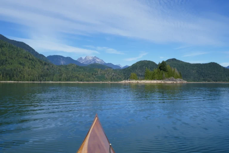
It had been on my paddling list for some time, but it wasn’t until I wound up on Texada one summer trip, staring down Sabine Channel, that a plan to actually get there began to form. Though I have almost a decade of experience as a professional kayak guide, I’m selective about my paddling destinations if I want to avoid renting a kayak. That’s because my personal kayak is a rudderless cedar-strip beauty that was made in the garage with my mom, and the old girl needs special treatment. Sheltered is best; pounding surf and high wind are out of the question. Every kayaker knows how obnoxious it is to have a boat that turns into the wind, where you end up compensating by paddling on one side until your arm is about ready to fall off.
And so, a couple of years later, I made the very long trip to Shingle Beach on Texada Island and slid my kayak into the calm waters. It was a sunny, bluebird day, the winds light and seas calm. I began making my way towards the enigmatic playground that was Jedediah Island.
No Easy Journey: Getting to Jedediah Island
Reaching Jedediah Island in a human-powered watercraft is difficult. It’s much easier with a sailboat or motorboat, but to paddlers, this feels a little like cheating. Dipping your way along a shoreline, in and out of little bays and rocks, watching birds, spotting porpoises, and finding secret beaches to lunch on is where the real fun happens.
Sabine Channel, which runs between Texada and Lasqueti, is an active shipping channel, which means that large vessels come through it often and quickly. It’s also angled a little Northwest-Southeast, which happens to be the prevailing wind directions in BC. So this makes it possible to get the brunt of any kind of high winds, in any weather conditions.
Before getting to my launch site on Texada, I first had to get there from the Lower Mainland, a journey which is, for lack of a better word, a long-ass day. The first time I made the trip, it took me eleven hours. Some of that was because of ferry delays, though not always a missed sailing. On that trip, a sewage truck had to come and suck the poop from the Texada ferry before we got on, a delay that resulted in a decidedly fragrant voyage.
At the time I’d done my reconnaissance mission, Shingle Beach Campground was overgrown, deserted, and honestly a little creepy. To my surprise, when I arrived for my Jedediah trip, it was tidy, mowed, had plenty of campers, and apparently a camp host. Another new addition was some fairly aggressive signage threatening to tow anyone who parked at the beach without paying fees, which seemed specifically directed at kayakers. Whoops.
Since the camp host wasn’t around and was also not answering texts, I grabbed myself a campsite for the night. To reduce my chances of being towed, the next morning, I parked way up by the entrance sign and left a note explaining that I had stayed one night and was happy to pay my camping and parking fees. Some of the locals reassured me that nobody was going to drive a tow truck all the way out there, but I still spent the entire trip worrying about it anyway.
Other ways to get to Jedediah Island:
- Experienced paddlers prepared for a long crossing and its associated hazards can launch from the Halfmoon Bay/Secret Cove area on the Sunshine Coast. The route most take is to the Thormanby islands, across Malaspina Strait, around the southern tip of Texada, and across Sabine Channel and up to Jedediah. Check out BC Marine Trails for launch sites on the Sunshine Coast.
- From the Vancouver Island side, some have made the journey by taking the passenger ferry from French Creek over to False Bay on Lasqueti. From there, a paddle around Lasqueti is required to reach Jedediah. Your biggest risk here is exposure to wind and fetch. Before going this route, check with Western Pacific Marine first to see if they can accommodate you. The ferry is walk-on only, and space is limited.
- For those who don’t want the drama of channel crossings and wind, there is a water taxi drop-off and pickup available from Thormanby Transportation.
- You could also potentially launch at Texada’s Shelter Point Campground, which would save taking your car down rough roads. Inquire with the campground hosts beforehand about overnight parking and associated costs.
Note: Paddlers planning a trip to Jedediah Island should be experienced and carry all safety gear as required by Transport Canada, as well as a marine communication device. Practical knowledge of weather, current, tides, as well as an understanding of the hazards of exposed crossings, shipping channels, and marine traffic, is essential.
A Fine Paddle
Handrailing along the rocky shore of Texada Island and then crossing Sabine Channel, it took me approximately three hours to reach Jedediah in sunny conditions with light winds (NW 5-15 kts).
There are two campsites on the island: Homestead Bay and Log Boom Bay. I arrived at the first to find that it was low tide, and therefore an oyster-filled mudflat. After paddling around the island, I found Log Boom Bay to be even worse. Circumnavigating back, I ran into another group who had arrived back at camp for the day, and was grateful for the help bringing my kayak up the beach.
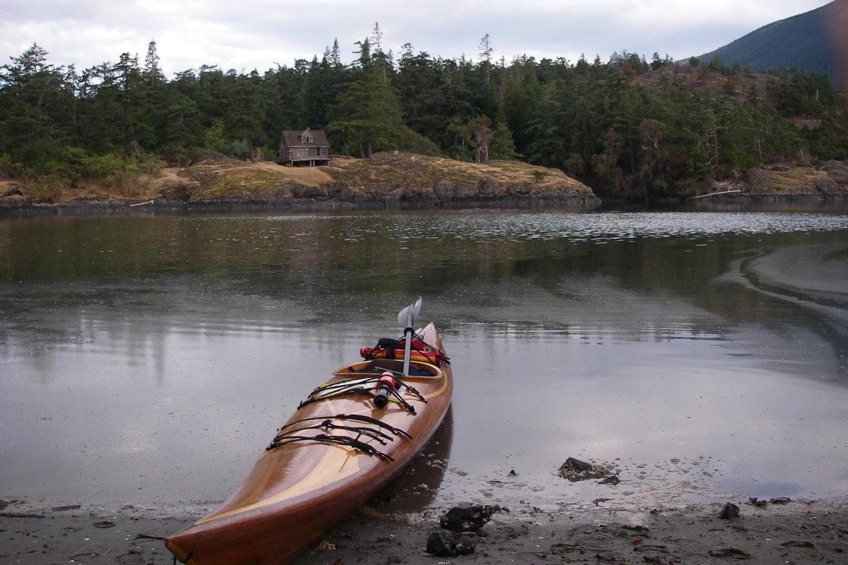
The next day, the winds were light at SE 5-15 kts, so I decided to meander up the ragged, inhospitable shoreline of Lasqueti Island to Potter Point. I was surprised to find that just about every little cove had a cabin, though none appeared inhabited. The island was very dry, and there were few places to land.
Though not terribly exciting, it was still a nice, relaxing day of exploring. I saw plenty of herons, eagles, kingfishers, and even otters. I lunched at Long Boom Bay, then made my way back towards camp. Near there, I finally spotted the feral goats on the bluffs near Codfish Bay. Wanting to make friends, I bleated at them just for fun, and though this got me a few curious looks, ultimately I was snubbed.
Exploring the Island
For the afternoon, I went exploring. The main trails around the island are wide, and there are numerous smaller ones, some difficult to distinguish from game trails. With the underbrush decimated by the feral animals, you can pretty well walk anywhere.
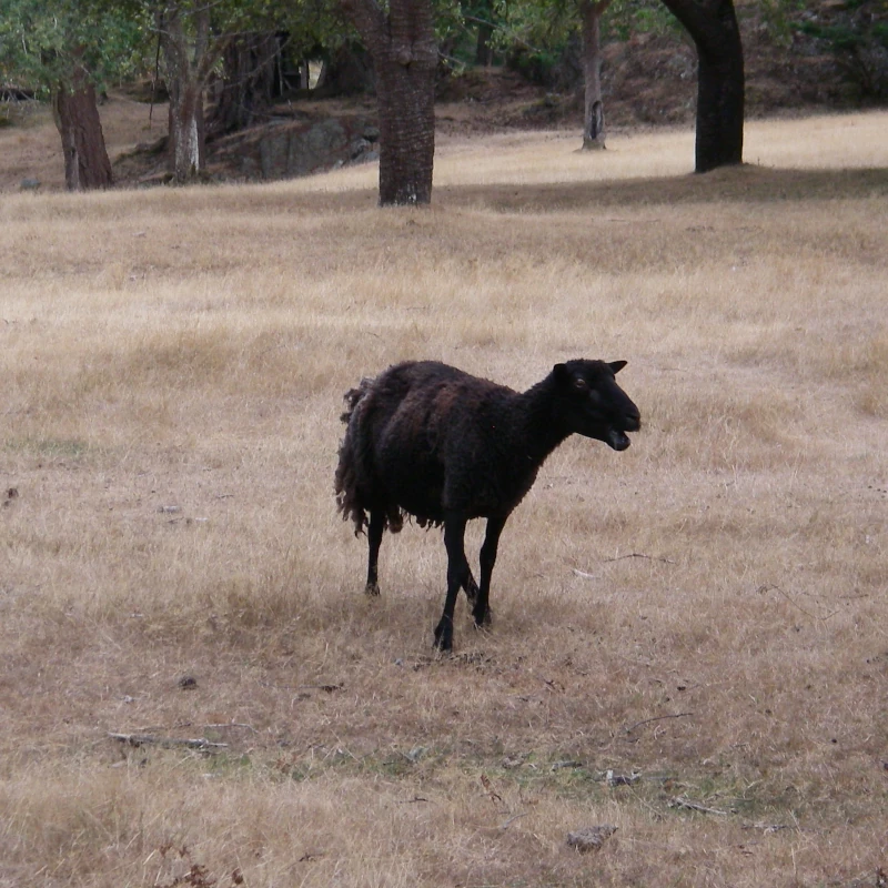
Around the other side of the bay was the old homestead, with a haunted-looking house, dilapidated outbuildings, and an old orchard. That was where the raggedy sheep liked to hang out. Since they’d picked clean all the lower branches of the trees and I wanted to make friends, I plucked a few apples and tossed them over. Though skittish, they quickly caught on to the game.
Looking for treasures, I also poked around the bluffs near Codfish Bay. I did find some bones that had me wondering if there was indeed a cougar on the island. If there was, it was probably the world’s fattest one, with all the snacks around.
Though they didn’t like to be near people, both the sheep and the goats would often come around the campsite to graze on the grass. The goats would hang out on the rocks at the back of camp. One, whom I dubbed Mr. Majestic, stood proudly posing on a rock, eyeing me suspiciously from beneath large horns.
A Windy Beach Day
The following day, I woke to strong southeasterlies, and as expected, conditions in the bay were lumpy. Tentbound in the morning, I was dismayed to discover that my trusty old tent, now sixteen years old, was leaking. Moving around the space and mopping up puddles of water gave me something to do, at least, and in between rainshowers, I went out and built a windbreak for my stove.
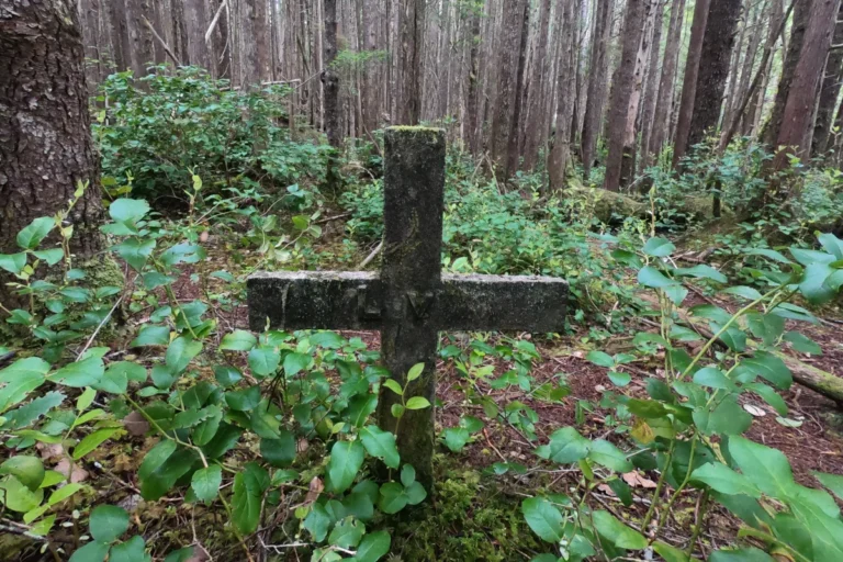
Later, when the rain had abated, I went for a walk to the other bays on the island. One of the places I wanted to go was the Gibraltar Viewpoint, but with only some vague directions, I couldn’t locate the path. One of the main trails passed by the grave of the old horse that lived on the island, Will, dotted with trinkets left behind by those paying their respects.
Exploring the rest of the island was fun. Down a side trail, I found a rope swing and gleefully played around on it, giggling like a kid again. Eventually, I ended up on the far end of the old field, now overgrown with sedges. There was something irresistibly whimsical about wandering through a field of long grass, so in a burst of silliness, I started running down the path, laughing, my arms out like Mara von Trapp in The Sound of Music.
I spent some time snooping around the woods on the outskirts of the orchard. When I was bored with that, I chucked some more apples for the sheep. All in all, it was a fun day on an incredible island.
At dawn the next morning, I heard footfalls rustling in the grass outside my tent and peeked out to see sheep there, grazing. The wind had calmed, and the day promised bright sunshine. Though initially I’d planned for one more day on Jedediah, I didn’t want to risk being stranded by the weather, so I decided to pack up and make the run back to Texada.
It was the perfect paddling day to end a trip. Gloriously sunny, blue skies, and best of all, nobody had towed my car. As soon as I was back to civilization, I was already hankering to go back. Jedediah is a bit magical that way. Far away, a little odd, steeped in history, and best of all, blissfully off the beaten path.
Can’t get away for a kayak trip? Check out our guide to The Best (and Worst) Places to Paddle in the Fraser Valley and find the perfect day trip.