The Sunshine Coast Trail: Bugs, Bad Knees, and Bliss
After being woken by an energetic dawn chorus at Sarah Point, I spent the better part of my first day on the Sunshine Coast Trail being pursued through fern-laden forest by a pack of enthusiastic mosquitoes. That night up on Manzanita Bluff, I could hear a cacophony of bullfrogs somewhere below. Though I was mosquito-bitten and thirsty, I’d already made up my mind that this was one of the best trails in the province.
Though it’s one of BC’s longest backpacking routes, the Sunshine Coast Trail is less famous than the West Coast Trail or the Berg Lake Trail. A hut-to-hut trail, it stretches 180 kilometres, winding through Powell River’s backcountry, its terrain ranging from sea level to 1300 metres. Built and maintained entirely by volunteers, it’s totally free.
Sunshine Coast Trail Quick Facts
Length: 180 km
Elevation: Sea level to 1300 m
Type: Multi-day; section hiking; hut to hut hiking
Cost: Free
Start: Sarah Point
End: Saltery Bay
Good for fear of heights: Yes
Maps: Printable/PDF, Digital
Book: The best place to purchase is the qathet Visitor Centre. Contact them for more info.
Harder Than You Think
I set out to tackle the SCT in 2022 and returned in 2023. Both times, the trail kicked my butt, or, rather, my knees. Because I left due to injury both years, this guide focuses on half of the trail, from Sarah Point to Tin Hat Mountain.
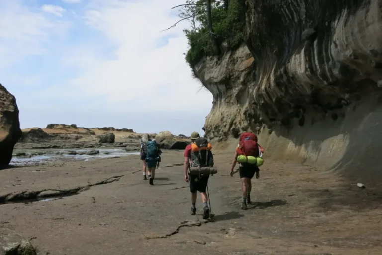
How long will it take to do the full trail, you ask? Well, that depends on your abilities and how much time you have. The best part about this trail is its many access points. This means that you don’t have to commit to completing the entire thing at once. I certainly didn’t. Having options also makes it accessible to all age groups and abilities. Those who want a challenge and can cover long distances can hike (or even run) the entire route in one go, while others can opt for shorter, flatter, more family-friendly sections. If you only have a day or two, there are plenty of options for overnighters, too.
Starting the trail means first finding a way to Sarah Point. You have two options here: taking a water taxi or taking the shuttle. Since the shuttle can get expensive, you’ll want a larger group if you’re considering that option. The benefit of taking the shuttle is that they have vehicles and equipment for safely navigating the active logging roads.
As for me, I parked my car at the Shingle Mill with a resupply in the trunk (parking cost: $5 per day), took the city bus to Lund, then hopped on a water taxi. Having come via ferry from the Lower Mainland, it was a full travel day, and when I arrived at Sarah Point, I was tired, and as thirsty as the mosquitoes who came out at dusk.
Water, Water Everywhere…or Nowhere?
It was around thirty degrees on my first day on the trail, so water access was a must. While there are a handful of year-round creeks on the trail, many others are seasonal. If it’s been a dry spring, or it’s later in the summer, they might already be low or dried up. My first year on the trail, the seasonal creeks were flowing. My second year, they were all dry, and the only water available was from the lakes.
With water not reliably available, and long distances between sources, this means carrying a significant amount, which adds weight to your pack and makes the trail more physically difficult.
We Canadians, as I found out, are massive snobs about drinking from lakes. An American couple I spoke to along the trail were baffled as to why none of us that they’d spoken to wanted to drink from the lakes. While it’s true that clear, flowing water is best, if that isn’t available, swallow your pride and drink from the lake (just treat or filter correctly).
The bottom line: plan to carry a significant amount of water over long distances.
Trail Highlights
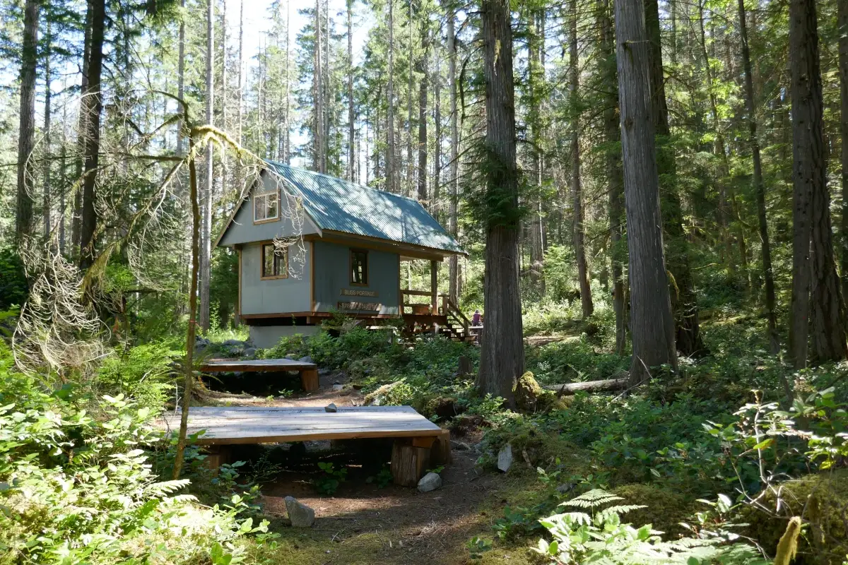
Honestly, everything was a highlight. Starting out at Sarah Point, you first go through dry coastal forest, but by Bliss Portage, you’re in proper temperate rainforest. It was absolutely gorgeous, and there were plenty of birds (bird nerd here).
It wasn’t terribly busy, either. While Sarah Point, Manzanita Bluff, and Tin Hat all had a good number of people, the other sites I had all to myself. Most of the people I ran into on the trail were just out for the day, and I was alone for most of my hike.
As someone who prefers the forest, my favourite campsite was, by far, Appleton Creek Rec Site. Nestled beside the creek with huge Douglas firs, the setting was idyllic, and I had it all to myself. Other campsites that caught my eye were Bliss Portage, Fern Crossing, and Sliammon Lake/Kokanee. Tin Hat was also spectacular, with stunning 360-degree views.
Another surprising highlight was the friendly people of Powell River. Everyone I chatted to was super interested in my trip. When I injured my knee, some kindly locals offered me a ride off the trail. I had yet another ride offer while waiting for the bus after leaving the trail the second time, and this was while holding a kitten that belonged to yet another friendly resident. The other bus passengers, the trail walkers, and even the nudists I ran into at Tony’s Point were all super nice.
Downsides were few, aside from annoying bullfrogs, and injuring myself and having to leave the trail on two different occasions. There were also a few places to stop for a swim, if you’re into that sort of thing. I’m not, but when it’s thirty degrees outside, sometimes you’ve just got to jump in a slimy lake with the bullfrogs.
Is the Sunshine Coast Trail Difficult?
Difficulty is subjective, so while I’m always reluctant to declare something to be one thing or another, I did find the Sunshine Coast Trail far more difficult than any other I’ve been on. Trail-wise, it’s not technical, but days are long, sometimes with lots of elevation gain. Bringing a tent along and not committing to sleeping in the huts gives you more options, but the long distances between campsites, combined with the variation in elevation, make it hard.
That said, whether you’re a long-distance runner or just someone out for a weekend, the SCT is beautiful, challenging, and totally worth it. Though I didn’t make it through to Saltery Bay on either of my attempts, the sections I did hike were more than enough for me to rank it as one of the best trails in the province. If you’re planning to give it a shot, be flexible with your plans, be prepared to carry large amounts of water, and enjoy the hike, bullfrogs, bugs, and all.
Leaving the trail early stinks, especially after having injured yourself. In my next article, I’ll share what my story and what I learned from the experience. (Link to be added when article is up.)
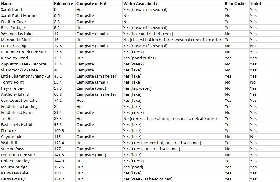
Sunshine Coast Trail Campsites, Water, and Amenities